Live Oak Peninsula Route
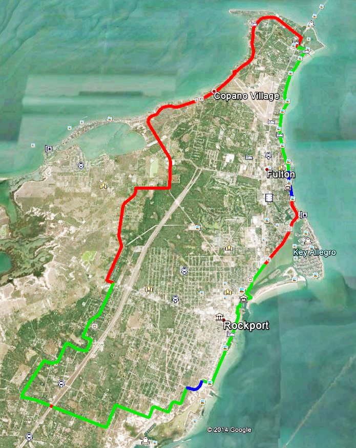
Loop 1781, Rockport, TX 78382 28°05’44.0″N 97°03’05.2″W (see map) Beginning at Howard Murph Park, this route encompasses most of Live Oak Peninsula and incorporates many of the sights and experiences found in the Fulton Harbor and Rockport Beach routes. Approximately 25 miles When cycling in Aransas County, as is the case on any public street, always wear a helmet and bright, highly visible clothing. It is also recommended to have a flashing red safety light mounted behind the saddle. Always ride with the flow of traffic, unless routes converge with sidewalks, and please obey all traffic laws and regulations. GREEN – HIGH EASE OF USE: Bike lanes, wide curbed lanes or low traffic volume residential streets. Some sidewalk connections.BLUE – MODERATE EASE OF USE: Generally low to moderate traffic volumes. May have wide outer lane, wide shoulder or shoulder with rumble strip.RED – LOW EASE OF USE: Higher traffic volumes, or narrow lanes with narrow shoulder or no shoulder, difficult connections for some cyclists. This link will download a kmz file which can be read and used by Google Earth to put all the Aransas Pathways Bike Trails on your map. Click here to download. Google Earth streams the world over wired and wireless networks enabling users to virtually go anywhere on the planet and see places in photographic detail. This is not like any map you have ever seen. This is a 3D model of the real world, based on real satellite images combined with maps, guides to restaurants, hotels, entertainment, businesses and more. You can zoom from space to street level instantly and then pan or jump from place to place, city to city, even country to country.Get Google Earth. Put the world in perspective.Google Earth is available here.
Aransas County Grand Tour Route
Starting Point – 121 Cove Harbor N, Rockport, TX 78382 (see map Beginning at Cove Harbor Marina, this bike route encompasses Aransas Pass, Fulton and Rockport. Points of interest along the route are Conn Brown Harbor in Aransas Pass, Howard Murph Park on Live Oak Peninsula, scenic Fulton Beach Road, the town of Fulton, historic town center of Rockport and scenic Water Street in Rockport. This entire route is an advanced ride for experienced cyclists, and many of the highlights of this ride can be found in the shorter routes designed for Aransas Pathways cyclists. Approximately 40 miles When cycling in Aransas County, as is the case on any public street, always wear a helmet and bright, highly visible clothing. It is also recommended to have a flashing red safety light mounted behind the saddle. Always ride with the flow of traffic, unless routes converge with sidewalks, and please obey all traffic laws and regulations. GREEN – HIGH EASE OF USE: Bike lanes, wide curbed lanes or low traffic volume residential streets. Some sidewalk connections.BLUE – MODERATE EASE OF USE: Generally low to moderate traffic volumes. May have wide outer lane, wide shoulder or shoulder with rumble strip.RED – LOW EASE OF USE: Higher traffic volumes, or narrow lanes with narrow shoulder or no shoulder, difficult connections for some cyclists. This link will download a kmz file which can be read and used by Google Earth to put all the Aransas Pathways Bike Trails on your map. Click here to download. Google Earth streams the world over wired and wireless networks enabling users to virtually go anywhere on the planet and see places in photographic detail. This is not like any map you have ever seen. This is a 3D model of the real world, based on real satellite images combined with maps, guides to restaurants, hotels, entertainment, businesses and more. You can zoom from space to street level instantly and then pan or jump from place to place, city to city, even country to country.Get Google Earth. Put the world in perspective.Google Earth is available here.
Connie Hagar
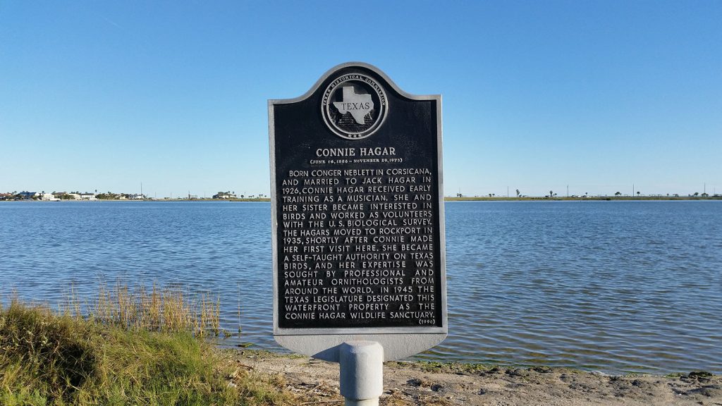
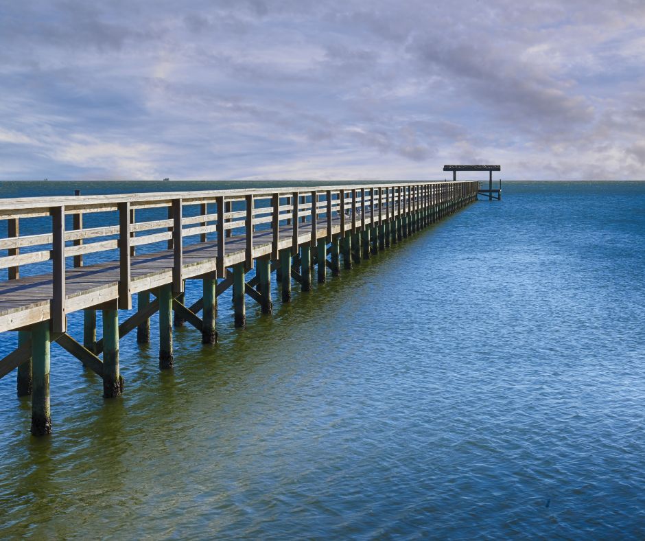
East of SH 35 (Broadway Street) at “Y” intersection, waterfront property facing Connie Hagar Wildlife Sanctuary, Rockport, TX 78382 (see map) MARKER TEXT (June 14, 1886 – November 29, 1973) Born Conger Neblett in Corsicana, and married to Jack Hagar in 1926, Connie Hagar received early training as a musician. She and her sister became interested in birds and worked as volunteers with the U.S. Biological Survey. The Hagars moved to Rockport in 1935, shortly after Connie made her first visit here. She became a self-taught authority on Texas birds, and her expertise was sought by professionals and amateur ornithologists from around the world. In 1945 the Texas Legislature designated this waterfront property as the Connie Hagar Wildlife Sanctuary. (1990)
First Baptist Church of Rockport
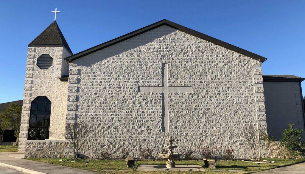
1515 N. Live Oak, Rockport, TX 78382 (see map) MARKER TEXT Organized in 1873, the First Baptist Church of Rockport originally was located on S. Church Street. L. D. Young served as the first pastor. The hurricane of 1919 destroyed the first church building, but the members built a new structure at the corner of Live Oak and Main Streets the following year. They joined with Rockport’s Methodist and Episcopal congregations to form an ecumenical Sunday School. Throughout its history, the First Baptist Church of Rockport has served the community with a variety of worship, educational, and outreach programs. (1991).
First National Bank of Rockport
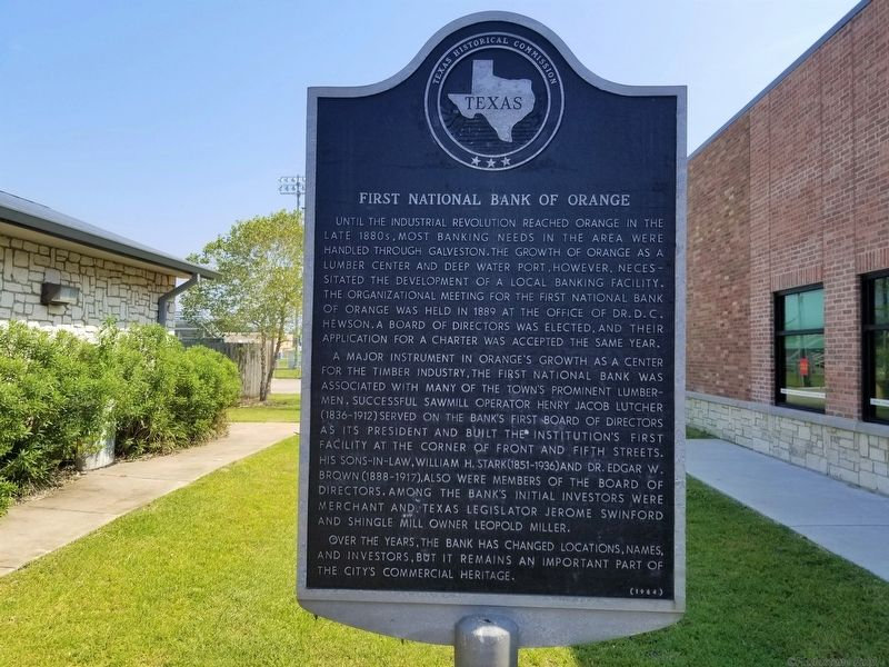
Corner of Austin and Liberty streets, Rockport, TX 78382 (see map) Chartered on October 8, 1890, the First National Bank of Aransas Pass (now Rockport) was organized by a group of businessmen led by John H. Traylor, James M. Hoopes, George W. Fulton, Jr., James C. Fulton, and Richard H. Wood. Located at Main and Water streets, the bank played a vital role in Rockport’s growth and development. Its name was changed to First National Bank of Rockport in 1903. After surviving both the 1919 storm and the Great Depression, the bank moved to new quarters across the street from its first location in 1958, and to this site in 1974. (1990).
Frandolig Island
1797 Bayshore Dr., Rockport, TX 78382 (see map) MARKER TEXT Dubbed “Nine Mile Point” by early settlers, this island was first used commercially by the Cushman Meat Packing Company in the late 1860s. Austrian Franz Joseph Frandolig, a horseman who had delivered cattle to Cushman & Co., homesteaded property at this site when the company vacated the land in 1878. Frandolig and his family established a large fig orchard. They sold the fruits and vegetables in Rockport and Fulton. Frandolig also kept a vineyard, where he produced and sold wine by the barrel, and built a salt works. The Frandolig family sold the property between 1901 and 1903. The severe hurricane of 1919 returned the island to its natural and uninhabited state. In 1958 the local navigation district began to offer it for development. (1999).
John Fagan
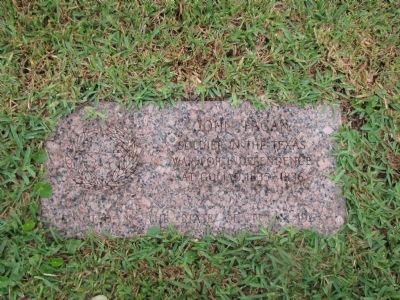
Lamar Cemetery, 222 Hagy Dr. Rockport, Tx 78382 (see map) MARKER TEXT Soldier in the Texas War for Independence at Goliad, 1835-1836. Old Lamar Cemetery, 7 mi. N on SH 35 to Goose Island State Park, follow P-13 east, then northeast 2.5 miles Rockport, Texas Marker Type: Civil War Memorials – (pink granite)
Baylor-Norvell House
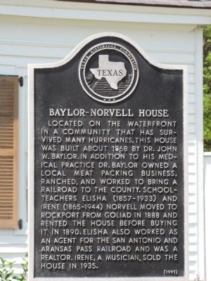
617 S. Water Street, Rockport, Tx 78382 (see map) MARKER TEXT Located on the waterfront in a community that has survived many hurricanes, this house was built about 1868 by Dr. John W. Baylor. In addition to his medical practice Dr. Baylor owned a local meat packing business, ranched, and worked to bring a railroad to the county. Schoolteachers Elisha (1857-1933) and Irene (1865-1944) Norvell moved to Rockport from Goliad in 1888 and rented the house before buying it in 1890. Elisha also worked as an agent for the San Antonio and Aransas Pass Railroad and was a realtor. Irene, a musician, sold the house in 1935. (1991).
Rockport Cemetery
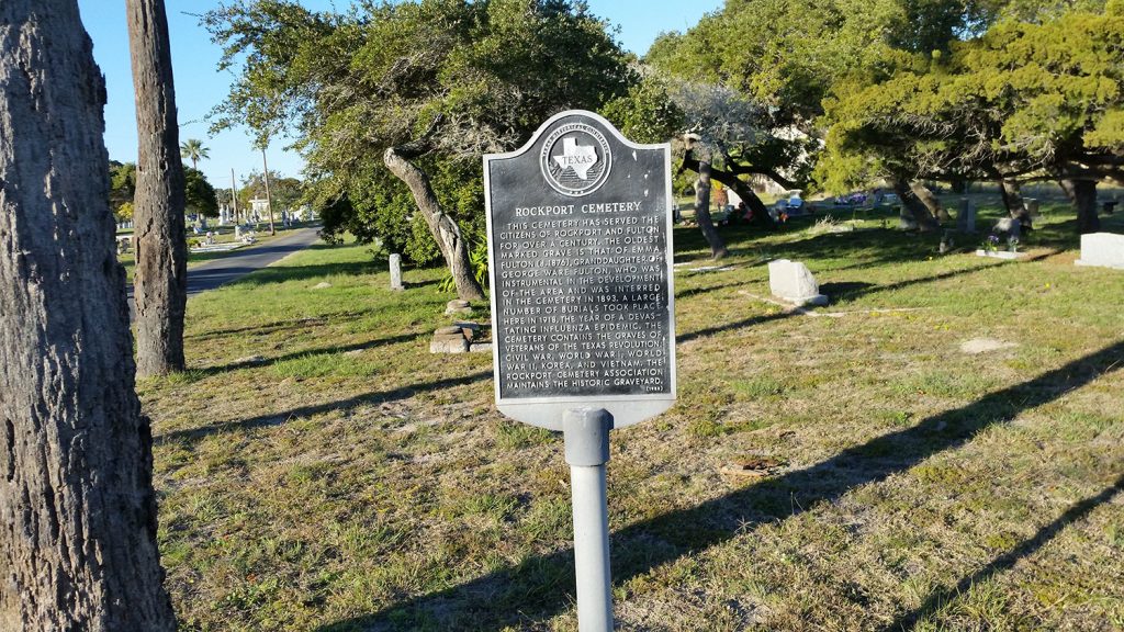
2040 Tule Park Dr, Rockport, TX 78382 (see map) MARKER TEXT This cemetery has served the citizens of Rockport and Fulton for over a century. The oldest marked grave is that of Emma Fulton (d. 1876), granddaughter of George Ware Fulton, who was instrumental in the development of the area and was interred in the cemetery in 1893. A large number of burials took place here in 1918, the year of a devastating influenza epidemic. The cemetery contains the graves of veterans of the Texas Revolution, Civil War, World War I, World War II, Korea, and Vietnam. The Rockport Cemetery Association maintains the historic graveyard. (1988).
Site of Heldenfels Shipyard
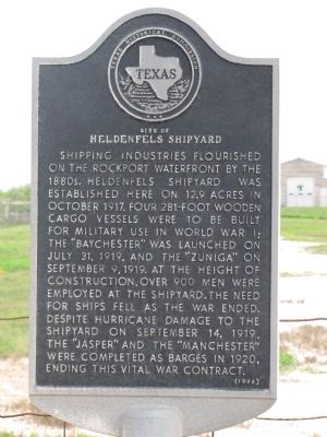
1800 S. Church Street (SH 70), Rockport, Tx 78382 (see map) MARKER TEXT Shipping industries flourished on the Rockport waterfront by the 1880s. Heldenfels Shipyard was established here on 12.9 acres in October 1917. Four 281-foot wooden cargo vessels were to be built for military use in World War I; the “Baychester” was launched on July 31, 1919, and the “Zuniga” on September 9, 1919. At the height of construction, over 900 men were employed at the shipyard. The need for ships fell as the war ended. Despite hurricane damage to the shipyard on September 14, 1919, the “Jasper” and the “Manchester” were completed as barges in 1920, ending this vital war contract. (1996).